महाराष्ट्र शासन | Government of Maharashtra
Whatsapp Number -  9307496148

History
The ancient name of Amravati is “Udumbravati”, prakrut form of this is “Umbravati” and “Amravati” is known for many centuries with this name. The mispronunciation form of this is Amravati and now the Amravati is known with the same. It is said that Amravati is named for its ancient Ambadevi temple. The ancient proof of existence of Amravati can get from stone carved inscription on the base of marble statue of God Adinath (Jain God) Rhishabhnath. This shows that, these statues were set up here in 1097. Govind Maha Prabhu visited Amravati in 13 th century, at the same time Warhad was under the rule of Deogiri’s Hindu King (Yadav).
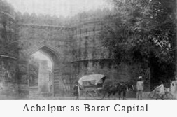
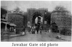
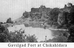
In 14th century, there was famine (drought) in Amravati & people abandoned Amravati and left for Gujrat and Malva. The local people were returned back after several years at Amravati, the result of this was scanty population. In 16 th century, Mager Aurangpura (today’s, ‘Sabanpura’) was presented for Jumma Majseed by Badashah Aurangzeb. This reveals that Muslims and Hindus lived together here. In 1722, Chhatrapati Shahoo Maharaj presented Amravati and Badnera to Shri Ranoji Bhosle, by the time Amravati was known as Bhosle ki Amravati. The city was reconstructed and prospered by Ranoji Bhosle after the treaty of Devgaon and Anjangaon Surji and victory over Gavilgad (Fort of Chikhaldara). The British general author Wellesly camped in Amravati, particular place is still recognized as camp, by Amravati people. The Amravati city came in to existence at the end of 18th century. Union state of Nizam and Bosale ruled the Amravati. They appointed the revenue officer, but defense system was worsted. Gavilgad fort was conquered by Britishers on 15th Dec’ 1803. According to the Deogaon treaty, the Warhad was presented as the token of the friendship to Nizam. The Warhad had Nizams monopoly, thereafter. Near about 1805, Pendharies attacked Amravati city.
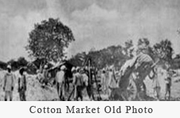
The Sahukars and Marchants of Amravati saved Amravati by giving seven lakhs to the Chittu Pendhari at that time.The Nizam ruled for a half century. The people enjoyed British rule instead of cruel Mugals (Nizam). From 1859 to 1871, many government buildings were come into existence, which were built by the Britishers. Railwaystation was constructed in 1859; commissioner bungalow in 1860, Small cause court in 1886, (today’s S.D.O. OFFICE), the Tahsil office & the Main post office were built in 1871. During this time, the central jail, collector office, Rest house, cotton market were also built. During 1896, Shri Dadasaheb Khaparde, Shri Ranganath Pant Mudhodker, Sir Moropant Joshi, Shri Pralhad Pant Jog were the leaders in Amravati.
The 13 th Congress Conference was held at Amravati on 27-29 Dec’ 1897 due to the efforts of these leaders. Shri Lokmanya Tilak and Shri Mahatma Gandhi visited Amravati in 1928. The Munsipal A.V. High School was inaugurated at the hands of Shri Subhash Chandra Bose. At the time of ‘Savinay Awagya Andolan ‘, Amravati held the head office of it. On 26 th of April 1930, the water was taken from ‘Dahihanda’ for the famous ‘Namak Satyagrah’, and Dr. Soman was brought the sea water from Mumbai for the occassion. Around ten thousand people were prepared the salt under the leadership of Shri Vir Vamanrao Joshi.
Udumbaravati was the encient name of today’s Amravati. It was due to the presence of ample number of Audumber trees in the region. The name was further abbrevated as Umbravati, Umravati& Amravati. The city grown up rapidly at the end of 18 th century due to the growth in businesses. It was one of the richest town of the area.
In 1853, the present day territory of Amravati district as a part of Berar Province was assigned to the British East India Company, following a treaty with the Nizam of Hyderabad. After the Company took over the administration of the province, it was divided into two districts. The present day territory of the district became part of North Berar district, with headquarters at Buldana. Later, the province was reconstituted and the territory of the present district became part of East Berar district, with headquarters at Amraoti. In 1864, Yavatmal District (initially known as Southeast Berar district and later Wun district) was separated. In 1867, Ellichpur District was separated but in August, 1905, when the whole province was reorganized into six districts, it was again merged into the district. In 1903, it became part of the newly constituted province of Central Provinces and Berar. In 1956, Amravati district became part of Bombay State and after its bifurcation in 1960, it became part of Maharashtra state.
Geography Amravati city is situated 340 m above from the sea level. Pohara & Chirodi hills are in the east of the city. Maltekdi is one of the hills, which is inside the city. The hight of Maltekdi is around 60 m & the statue of great maratha king , Chhatrapati Shivaji Maharaj is placed on the top of the hill. There are two lakes in the eastern part of the city, namely, Chhatri Talao & Wadali Talao. The city is located in the East Maharashtra on the altitude of 20o 56′ north & 77o 47’ east. It is the main centre of west Vidarbha. It is on the Mumbai-Calcutta high way.
Teosa History
Teosa (Tivsa) – Overview
Location: Teosa, also spelled Tivsa or Tiosa, is a town and tehsil in the Amravati district of Maharashtra, located in the Vidarbha region.
Geography: It is situated about 30–35 km from Amravati city. The area is predominantly agricultural, with major crops including cotton, soybean, and chickpeas.
Administration: Teosa is the administrative center of the tehsil, with facilities like the Tehsil Office, Police Station, schools, and colleges. It falls under the Teosa Vidhan Sabha (Legislative Assembly) constituency.
Population & Language: The primary language spoken here is Marathi. The population is moderate and diverse, with people from different communities living together.
Education: The town has a mix of government and private schools and a few colleges. The literacy rate is gradually improving in the region.
Transportation: Teosa is well-connected by road to cities like Amravati and Nagpur. The nearest railway stations are Amravati and Badnera.
Teosa (also known as Tivsa) is a town located in the Amravati district of Maharashtra, India, with a rich historical background. Here's a brief history of Teosa/Tivsa:
1. Ancient History: Teosa has historical significance dating back to ancient times. It is believed to have been an important settlement during earlier centuries. The region is known to have had a presence of local dynasties and rulers who contributed to its development.
2. Geographical Significance: Teosa is situated near the Wardha River, which made it a strategic location for trade and transportation in ancient times. The town’s proximity to important trade routes helped it flourish in its early days.
3. Religious Importance: The town is home to several temples, with a prominent focus on local deities and Hindu worship. The presence of temples like the Shri Mahadev Mandir (Shiva Temple) adds to its religious importance.
4. Medieval Period: During the medieval period, Teosa was likely under the rule of Maratha or other regional powers. The Marathas had a significant presence in this region, influencing the culture, architecture, and administration of the time.
5. Modern Development: In modern times, Teosa has grown into a small town with agricultural activities as the mainstay of the local economy. The town has seen gradual development in terms of infrastructure, with an increase in educational institutions and basic amenities.
Though the specific historical details of Teosa/Tivsa may not be as well-documented as some larger cities in Maharashtra, it remains an important town in the region, with its cultural heritage and historical legacy playing a role in the region's overall development.
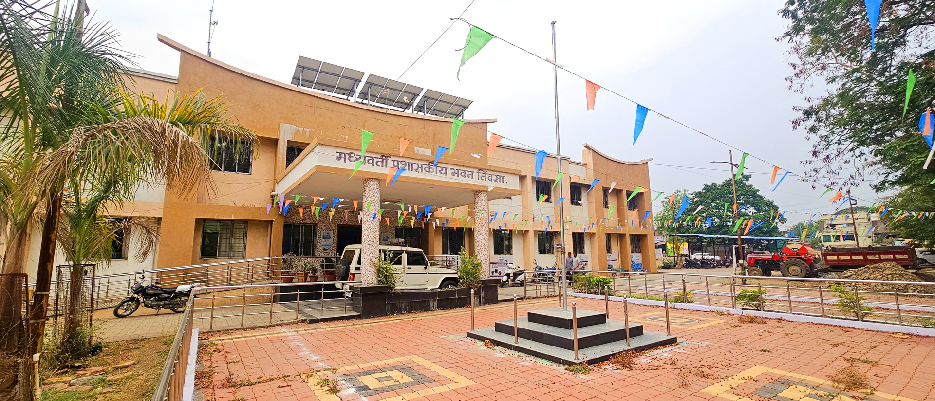
New Administrative Building, Surwadi Budruk, Tal.Teosa, Dist. Amravati,Maharashtra
![]() 9307496148
9307496148